Dive slate · divesites.com.au · printed 9 Nov 2026
SS Northern Firth
Ulladulla, New South Wales · near Bawley Point
| Depth | 15–26 m |
|---|---|
| Minimum level | Advanced Open Water |
| Difficulty | Intermediate |
| Access | Boat |
| Entry | Giant stride from anchored boat |
| Current | Mild |
| Visibility | 8–15 m m |
| Water | summer 19–22 °C °C, winter 13–16 °C °C |
| Suit | 7 mm wetsuit with hood most of the year (5 mm adequate Feb–Apr); semi-dry or drysuit and gloves Jul–Oct |
| Best season | Late summer to early winter on calm westerly days |
| Bottom time | 35 min |
| Position | -35.52631, 150.41545 (GPS) |
| Permit | Batemans Marine Park; Brush Island grey nurse shark critical habitat special rules apply – check current zoning map. Historic shipwreck protection applies. |
| Nearest chamber | Prince of Wales Hospital Hyperbaric Unit (Randwick, Sydney) |
| Emergency | 000 · DAN Asia-Pacific diving emergency 1800 088 200 |
SS Northern Firth
Also known as Northern Firth wreck, Brush Island wreck, SS Willowpark
Swim through a giant intact boiler from a 1932 steamer wrecked on Brush Island.
Near Bawley Point · Ulladulla, New South Wales
- Depth
- 15–26 m
- Minimum level
- Advanced Open Water
- Access
- Boat
- Boat ride
- ~45 min
- Water
- 19–22 °C
- Visibility
- 8–15 m
SS Northern Firth15–26 m · Advanced Open Water
Dive factsDepths, conditions, location & safety
Season
Off-peak nowBest months: January, February, June, July, August, December.
Late summer to early winter on calm westerly days
- Best months
- Now (November)
Dive facts
- Depth
- 15–26 m
- Typical depth
- 20 m
- Certification
- Advanced Open Water
- Difficulty
- Intermediate
- Depth tier
- Advanced Open Water (18–30 m)
- Access
- Boat
- Offshore
- 0.8 km
- Dive centre needed
- Yes – boat access only
- Shore / independent
- No
- Boat ride
- ~45 min
- Current
- Mild
- Visibility
- 8–15 m
- Water temp (summer)
- 19–22 °C
- Water temp (winter)
- 13–16 °C
- Water
- Temperate
- Bottom time
- 35 min
- Dive traffic
- Rarely dived (private boat/club only)
- Night dive
- No
- Snorkel friendly
- No
Exposure suit
7 mm wetsuit with hood most of the year (5 mm adequate Feb–Apr); semi-dry or drysuit and gloves Jul–Oct
Location
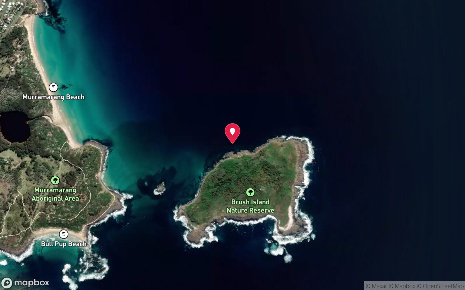
Brush Island (Murramarang) · Ulladulla – Mollymook & Bawley Point
-35.52631, 150.41545
Published GPS position.
Open in Google MapsPrimary source: michaelmcfadyenscuba.infoMarine park & permits
Batemans Marine Park; Brush Island grey nurse shark critical habitat special rules apply – check current zoning map. Historic shipwreck protection applies.
Nearest recompression chamber
Prince of Wales Hospital Hyperbaric Unit (Randwick, Sydney)
Diving emergency: call 000, then DAN AP 1800 088 200.
Trip planner
Build a trip around SS Northern Firth →
A day-by-day plan for Ulladulla with this site locked in.
This guide is a planning aid. Conditions change daily — confirm with a local dive centre and dive within your training. Data & safety notes.
Dive profile
How this site rates
Scores are computed from the recorded data, not opinions. How?
At a glance
SS Northern Firth is a wreck boat dive in Ulladulla, NSW, 15–26 m, suited to Advanced Open Water divers, about 45 minutes by boat.
Rated intermediate because of depth beyond 18 m, surge on the entry or in the shallows, cold water.
Why dive here
- Swim through a giant intact boiler from a 1932 steamer wrecked on Brush Island.
- Sunk in 1932; protected as underwater cultural heritage, so look but do not touch.
- Rarely dived: expect to have the site to yourself, and plan your own logistics.
Conditions to avoid
- Strong southerly or south-east swell and wind
- Afternoon north-easterlies
- Outgoing tide or run-off after rain (poor visibility)
About SS Northern Firth
The SS Northern Firth was built in 1922 at the Grangemouth Dockyard in Scotland as the SS Willowpark and renamed by 1932. She was a 1,931-gross-ton steel steamer, 280 feet long and 42 feet wide, with a single triple-expansion engine, owned by the North British Shipping Company and chartered to James Patrick and Company. On 21 February 1932 she struck a submerged reef just off Brush Island, south of Bawley Point. A hole was torn in her side and the engine room flooded quickly. Strong north-easterly winds then drove her onto the north-eastern corner of the island. All the crew reached shore safely.
The cargo, valued at £90,000, included shoes, clothing, liquor, beer, glycerine and syrup, and locals helped themselves before a wreck guard arrived. Salvors worked the wreck from 25 February to 10 March 1932, by which time she was breaking up quickly. A Marine Court of Inquiry cleared the second mate because the reef was not on the Admiralty chart.
Today the Northern Firth is a scatter of rusted steel plates and frames on the reef and sand beside the island, with some pieces visible on the island and the mainland shore. The one substantial feature is a huge boiler, still lying as it would in the ship, which is wide enough for divers to swim through side by side. McFadyen dived it in 1993 and then failed to find it again in 1995 and 1996. The Marine Life Network gives the boiler depth as 26 m, while other accounts suggest much of the wreckage is shallower. Surrounding reef carries kelp, sponges and schools of reef fish. Brush Island is in the Batemans Marine Park and is also grey nurse shark habitat. It is a long trip for a scattered wreck, so the site mainly suits divers interested in wrecks and history.
Wreck details
Steel steamship (ex-SS Willowpark), 280 ft (85 m), 1,931 GRT, triple-expansion engine; built Grangemouth 1922 · Sunk 1932 · Protected historic shipwreck
Era: early 20th century. Oldest wrecks · Wartime wrecks · Scuttled warships
Other wrecks of the same era
- MV Malabar wreck (Long Bay) · Max 10 m · Sydney South & Botany Bay
- PS Commodore wreck · Max 36 m · Newcastle & Lake Macquarie
- SS Irresistible wreck · Max 26 m · Newcastle & Lake Macquarie
- SS Osprey wreck · Max 42 m · Newcastle & Lake Macquarie
- SS Annie M. Miller wreck · Max 46 m · Sydney South & Botany Bay
- TSS Merimbula · Max 14 m · Shoalhaven Coast
Getting there & entry
Scattered remains of a 1922 steel steamer wrecked on the north-eastern corner of Brush Island off Murramarang Beach, south of Bawley Point; the main feature is a large boiler you can swim through.
Boat access only. From Ulladulla Harbour the boat runs about 20 km south past Bawley Point to Brush Island, which sits just off Murramarang Beach; allow about 45 minutes. Batemans Bay boats (Hanging Rock ramp) can also reach it, heading north past Durras.
McFadyen's GPS mark was supplied by Derek Hickey in 2010, and he notes that most of the wreckage seems to be about 20 m west of the mark. Anchor clear of the wreckage on sand or rubble.
Entry: Giant stride from anchored boat
Weather, swell & tides
Brush Island is exposed to north-east and south-east swell, and it was a north-easterly that drove the ship onto the island. The 45-minute run from Ulladulla means you need a settled forecast: less than about 1.5 m of swell and light westerlies or north-westerlies. Southerly changes arrive quickly on this coast; watch the forecast and be prepared to head home.
The shallow reef south-east and east of the island breaks in bigger swell. Visibility is lower after heavy rain from nearby lagoons and creeks.
Best season: Late summer to early winter on calm westerly days
If it's blown out
Sheltered or shore sites within 25 km that often work when SS Northern Firth doesn't.
- Bawley Point · 2 km · Max 13 m
- Pretty Beach (Murramarang) · 6 km · Max 10 m
- Pebbly Beach (Murramarang) · 12 km · Max 10 m
- Dolphin Point · 14 km · Max 12 m
How the dive is usually run
Descend near the mark and search about 20 m west for the boiler, the most substantial piece of wreckage. Swim through the boiler if your buddy team is comfortable, then follow the scatter of plates and frames towards the island. Keep an eye on depth and gas, and return to the anchor line for the ascent.
Marine life
- Yellowtail
- silver sweep
- eastern blue devilfish →
- blue groper →
- wobbegongs →
- kelp
- sponges; occasional grey nurse sharks (Brush Island is grey nurse critical habitat) →
Linked species have their own page listing every site where they are recorded. All marine life →
Training required
Beyond 18 m an Advanced certification (which includes a deep dive to 30 m) is the accepted minimum. Anything past 25 m is a deep dive in practice.
At more than 25 m this counts as a deep dive: watch no-decompression limits and gas.
Courses that help here
- Enriched Air Nitrox – Longer no-decompression time at 25 m and deeper.
- Drysuit Diver – Cold water; locals dive dry for much of the year.
- Peak Performance Buoyancy – Silt and low visibility punish poor trim.
Depth tiers: 0–10 m easy · to 18 m Open Water · 18–30 m Advanced (25 m+ is a deep dive) · 30–40 m Deep specialty · 40 m+ technical. All courses
Hazards & warnings
Long exposed run from Ulladulla, with rapid southerly changes. Sharp, rusting steel. Don't enter the boiler if there is surge.
Grey nurse shark critical habitat rules apply around Brush Island. Location uncertain (several failed searches), so allow time to find it.
Technical notes
Wreck is a historic shipwreck (over 75 years old) protected under the Underwater Cultural Heritage Act 2018: look, do not take.
Dive centres that go here
Dive Adventures Ulladulla lists Brush Island (wreck dives, max 25 m+, experience required) and runs it occasionally when seas allow. Otherwise private boats from Ulladulla or Batemans Bay and visiting clubs.
Operators recorded for SS Northern Firth
Beneath the Bay
Named by sitesBatemans Bay · Batemans Bay · NSW
Boat-based dive/snorkel charter; departs Hanging Rock boat ramp.
beneaththebay.com.au · 0405 838 957
Dive Adventures Ulladulla
Named by sitesUlladulla · Ulladulla · NSW
Official site live (PADI 5 Star, 6 Aroo Rd Ulladulla); listing updated June 2026, though no dated 2025–26 reviews seen.
diveadventuresulladulla.com.au · (02) 4455 3029
Map
7 pinned sites. Pins marked approximate on their pages show the general area only; not for navigation.
Satellite views
SS Northern Firth: frequently asked questions
How deep is SS Northern Firth?
SS Northern Firth reaches a maximum depth of 26 m, with the shallowest part at about 15 m; most of the dive is spent around 20 m.
What certification do I need to dive SS Northern Firth?
Advanced Open Water is the recommended minimum. At more than 25 m this counts as a deep dive: watch no-decompression limits and gas. Rated intermediate because of depth beyond 18 m, surge on the entry or in the shallows, cold water.
Can I shore dive SS Northern Firth?
No, it is reached by boat (about 45 minutes). A dive centre is required: boat access only.
When is the best time to dive SS Northern Firth?
Late summer to early winter on calm westerly days.
What marine life will I see at SS Northern Firth?
Regularly recorded: Yellowtail, silver sweep, eastern blue devilfish, blue groper, wobbegongs, kelp, sponges; occasional grey nurse sharks (Brush Island is grey nurse critical habitat).
What wetsuit do I need at SS Northern Firth?
7 mm wetsuit with hood most of the year (5 mm adequate Feb–Apr); semi-dry or drysuit and gloves Jul–Oct.
How cold is the water at SS Northern Firth?
Typically 19–22 °C in summer and 13–16 °C in winter.
What are the main hazards at SS Northern Firth?
Long exposed run from Ulladulla, with rapid southerly changes. See the hazards section above for the full list.
Where is the nearest recompression chamber to SS Northern Firth?
Prince of Wales Hospital Hyperbaric Unit (Randwick, Sydney). In an emergency call 000, then DAN Asia-Pacific on 1800 088 200.
Diving in Ulladulla
Ulladulla is the quiet middle of the south coast, with the Lighthouse Reef and the Bommie off Warden Head, the Burrill Rocks, and a series of gutters and caves that hold grey nurse sharks and eastern blue devils. It is dived mainly by locals and Canberra clubs.
Getting there: Three hours south of Sydney. A local dive shop runs charters from the harbour; the Ulladulla harbour breakwall is a sheltered shore dive.
Sources
- michaelmcfadyenscuba.info/viewpage.php?page_id=653
- marinelife.org.au/?page_id=1659
- diveadventuresulladulla.com.au
- dpird.nsw.gov.au/fishing/marine-protected-areas/marine-parks/batemans-marine-park/scuba-diving-and-snorkeling
Data confidence: Medium · Being verified: Depths: MLN gives 30 m max and boiler at 26 m; McFadyen gives no depth. Check current condition.. Last updated September 2026. Know this site better? How to send a correction
Nearby dive sites
More wrecks in New South Wales
Explore more
This region
Similar dives
Marine life