Dive slate · divesites.com.au · printed 8 Nov 2026
Bay of Islands
Shipwreck Coast & Warrnambool, Victoria · near Peterborough
| Depth | 2–20 m |
|---|---|
| Minimum level | Advanced Open Water |
| Difficulty | Intermediate |
| Access | Boat |
| Entry | Giant stride from a small boat anchored on sand between the stacks; the narrow beach at Boat Bay allows a swim-out on very calm days |
| Current | Moderate |
| Visibility | 5-15 m |
| Water | summer 16-19 °C, winter 11-14 °C |
| Suit | 7mm semi-dry with hood and gloves in summer; drysuit strongly preferred May–November |
| Best season | Autumn (Mar–May) and settled summer days at high tide |
| Bottom time | 40 min |
| Position | -38.58250, 142.82177 (GPS) |
| Permit | Bay of Islands Coastal Park (land); waters outside marine protected areas – Victorian bag limits apply |
| Nearest chamber | The Alfred (Melbourne) |
| Emergency | 000 · DAN Asia-Pacific diving emergency 1800 088 200 |
Bay of Islands
Also known as Boat Bay, Bay of Islands Coastal Park
Circle the bases of limestone sea stacks in 10–20 m with crays in every undercut – Twelve Apostles scenery underwater, with a boat ramp and no crowds.
Near Peterborough · Shipwreck Coast & Warrnambool, Victoria
- Depth
- 2–20 m
- Minimum level
- Advanced Open Water
- Access
- Boat
- Boat ride
- ~5 min
- Water
- 16-19 °C
- Visibility
- 5-15 m
Bay of Islands2–20 m · Advanced Open Water
Dive factsDepths, conditions, location & safety
Season
Off-peak nowBest months: January, February, March, April, May, December.
Autumn (Mar–May) and settled summer days at high tide
- Best months
- Now (November)
Dive facts
- Depth
- 2–20 m
- Typical depth
- 10 m
- Certification
- Advanced Open Water
- Difficulty
- Intermediate
- Depth tier
- Advanced Open Water (18–30 m)
- Access
- Boat
- Offshore
- 0.5 km
- Dive centre needed
- Recommended
- Shore / independent
- Possible (experienced only)
- Boat ride
- ~5 min
- Current
- Moderate
- Visibility
- 5-15 m
- Water temp (summer)
- 16-19 °C
- Water temp (winter)
- 11-14 °C
- Water
- Temperate
- Bottom time
- 40 min
- Dive traffic
- Rarely dived (private boat/club only)
- Night dive
- No
- Snorkel friendly
- Partial
Exposure suit
7mm semi-dry with hood and gloves in summer; drysuit strongly preferred May–November
Location
Bay of Islands Coastal Park · Shipwreck Coast – Peterborough
-38.58250, 142.82177
Published GPS position.
Open in Google MapsPrimary source: scubadoctor.com.auMarine park & permits
Bay of Islands Coastal Park (land); waters outside marine protected areas – Victorian bag limits apply
Nearest recompression chamber
The Alfred (Melbourne)
Diving emergency: call 000, then DAN AP 1800 088 200.
Trip planner
Build a trip around Bay of Islands →
A day-by-day plan for Shipwreck Coast & Warrnambool with this site locked in.
This guide is a planning aid. Conditions change daily — confirm with a local dive centre and dive within your training. Data & safety notes.
Dive profile
How this site rates
Scores are computed from the recorded data, not opinions. How?
At a glance
Bay of Islands is a reef shore dive for experienced divers in Shipwreck Coast & Warrnambool, VIC, 2–20 m, suited to Advanced Open Water divers, moderate current, about 5 minutes by boat.
Rated intermediate because of depth beyond 18 m, surge on the entry or in the shallows, boat traffic overhead, cold water.
Why dive here
- Circle the bases of limestone sea stacks in 10–20 m with crays in every undercut – Twelve Apostles scenery underwater, with a boat ramp and no crowds.
- Rarely dived: expect to have the site to yourself, and plan your own logistics.
About Bay of Islands
The Bay of Islands is the place the Bay of Islands Coastal Park is named for: an irregular, semi-circular bay 5 km west of Peterborough with a dozen or more large limestone stacks and islands scattered across it, together with reefs and rocks, below 10–20 m limestone bluffs. It has the drama of the Twelve Apostles with a fraction of the visitors, and unlike the Apostles it has a boat ramp. Underwater the stacks are limestone pillars rising from a sand and reef floor in 10–20 m, their bases undercut into ledges, overhangs and small caves and their walls covered in kelp on the lit faces and sponges, ascidians, bryozoans and hydroids in the shade. Sand channels run between them. Crayfish are abundant in the undercuts, abalone on the lower walls, and the fish life is rich for the coast: blue-throat and senator wrasse, magpie perch, sea sweep in schools, zebrafish, herring cale, boarfish under the ledges, Port Jackson sharks and rays on the sand, and Australian fur seals from the Lady Julia Percy and Cape Bridgewater colonies passing through. In settled autumn water with 10–15 m visibility, circling the base of one of the big stacks with the light coming through the kelp is as good as anything on the Victorian open coast.
The Scuba Doctor lists it at 2–20 m for Open Water and beyond and notes plenty of interesting structure to explore; the practical constraint is that the bay is less sheltered than Crofts Bay next door and the currents between the stacks pick up when the outer reefs are breaking. It is essentially a private-boat site, launched from the ramp at Boat Bay at high tide on a low swell, and it rewards a group with their own boat and a settled forecast far more than a casual visit. A dive flag is essential because the ramp is busy with cray boats in season. For most visitors the bay will be a lookout; for a few it is one of the best-kept secrets of the Shipwreck Coast.
Getting there & entry
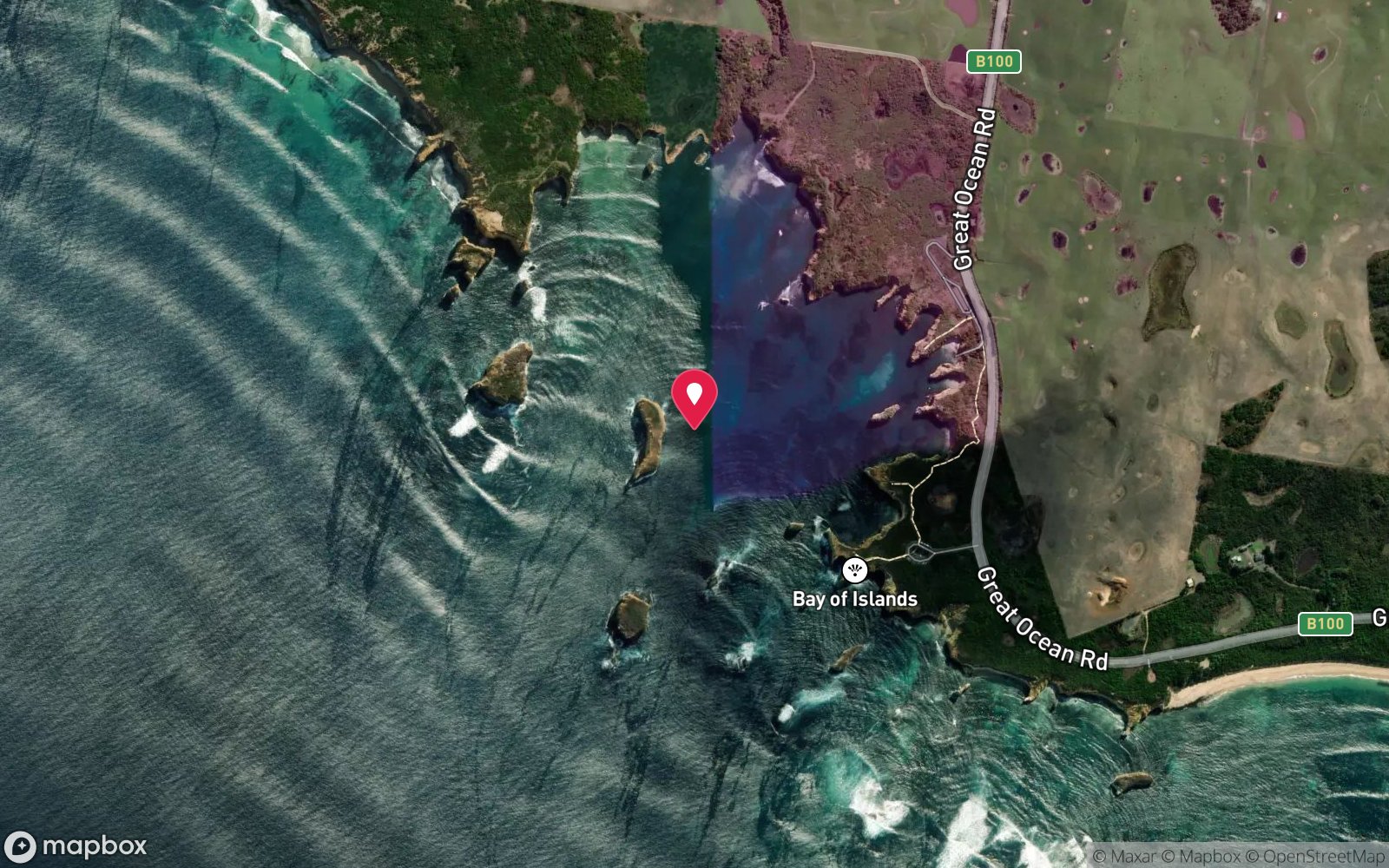
Semi-circular bay studded with large limestone sea stacks and reefs, 5 km west of Peterborough, with the Boat Bay boat ramp at its eastern end; depths 2–20 m among the stacks.
From Peterborough drive 5 km west on the Great Ocean Road and turn left onto Boat Bay Road, which leads down to the Bay of Islands boat ramp, car park and picnic area at Boat Bay. The ramp gives direct access to the stacks and reefs of the bay, most of which are within 500 m to 1 km of the ramp – a five-minute run. The beach beside the ramp is narrow and reached by a ramp and steps, and on a flat day divers snorkel out from it, but the bay is best treated as a boat dive.
Warrnambool (45 km) is the nearest dive shop and air.
Entry: Giant stride from a small boat anchored on sand between the stacks; the narrow beach at Boat Bay allows a swim-out on very calm days
Facilities: Boat Bay ramp with trailer parking, toilets and picnic area; Peterborough general store and pub 5 km; no air fills nearer than Warrnambool.
Weather, swell & tides
Best dived at high tide when the reefs are fully submerged. The bay is less sheltered than Crofts Bay; the outer reefs break heavily in any swell and, when they do, currents run between the stacks. Aim for a south-west swell under about 1 m with light northerly winds; southerly and westerly winds and bigger swell make launching at Boat Bay and manoeuvring between the stacks dangerous.
The beach itself is generally calm because of the reef filtration, which is deceptive – check the outer stacks for white water before launching. Visibility clears after a few days of northerlies in autumn. Boat traffic from the ramp requires a dive flag.
Best season: Autumn (Mar–May) and settled summer days at high tide
If it's blown out
Sheltered or shore sites within 25 km that often work when Bay of Islands doesn't.
- Bay of Martyrs · 4 km · Max 10 m
- Falls of Halladale · 4 km · Max 12 m
- Antares · 6 km · Max 6 m
- Schomberg · 7 km · Max 10 m
How the dive is usually run
Anchor on sand in the lee of one of the larger stacks in 10–15 m, descend and circle its base, working the overhangs, small caves and ledges at the foot of the wall, then cross the sand to a neighbouring stack if visibility allows. Keep the anchor position fixed with a compass bearing, turn at half gas and return for a 3-minute stop on the line. Watch for current between the stacks on a falling tide.
Marine life
- Southern rock lobster (abundant)
- black-lip abalone
- blue-throat and senator wrasse
- magpie perch
- sea sweep
- zebrafish
- herring cale
- longsnout boarfish
- Port Jackson sharks →
- smooth rays
- Australian fur seals (transient) →
- kelp
- sponges
- ascidians
- bryozoans
Linked species have their own page listing every site where they are recorded. All marine life →
Training required
Beyond 18 m an Advanced certification (which includes a deep dive to 30 m) is the accepted minimum. Anything past 25 m is a deep dive in practice.
Open Water divers can dive the shallower section (typical depth 10 m); the full site to 20 m needs Advanced Open Water. Operators often quote Open Water.
Operators' own listing: Open Water.
Courses that help here
- Drysuit Diver – Cold water; locals dive dry for much of the year.
- Underwater Navigation – Navigation is part of the dive plan.
Depth tiers: 0–10 m easy · to 18 m Open Water · 18–30 m Advanced (25 m+ is a deep dive) · 30–40 m Deep specialty · 40 m+ technical. All courses
Hazards & warnings
Outer reefs break heavily in swell; currents between the stacks; boat traffic at the Boat Bay ramp – dive flag mandatory; surge at the stack bases; rapidly changing conditions; remote. Victorian bag limits apply.
Dive centres that go here
No regular operator – private boats launched at Boat Bay, Warrnambool Diving and club trips on calm days.
Operators recorded for Bay of Islands
Other dive centres in Shipwreck Coast & Warrnambool
Daktari Sport (Daktari Surf & Dive)
Named by sitesPort Fairy · Shipwreck Coast & Warrnambool · VIC
Website live for 2026 with current PADI course prices; stores in Port Fairy, Hamilton and Mount Gambier.
daktarisport.com.au
Port Campbell Boat Charters
Named by sitesPort Campbell · Shipwreck Coast & Warrnambool · VIC
Listed at 32 Lord St Port Campbell offering scenic, fishing, snorkelling and diving trips; a listing says tours were suspended for pier maintenance and current status is unconfirmed.
portcampbellboatcharters.com.au · 0428 986 366
Map
7 pinned sites. Pins marked approximate on their pages show the general area only; not for navigation.
Satellite views
Bay of Islands: frequently asked questions
How deep is Bay of Islands?
Bay of Islands reaches a maximum depth of 20 m, with the shallowest part at about 2 m; most of the dive is spent around 10 m.
What certification do I need to dive Bay of Islands?
Advanced Open Water is the recommended minimum. Open Water divers can dive the shallower section (typical depth 10 m); the full site to 20 m needs Advanced Open Water. Operators often quote Open Water. Rated intermediate because of depth beyond 18 m, surge on the entry or in the shallows, boat traffic overhead, cold water.
Can I shore dive Bay of Islands?
Experienced divers do dive Bay of Islands from the shore, but the entry or conditions make it unsuitable for newer divers without local guidance. Entry: Giant stride from a small boat anchored on sand between the stacks; the narrow beach at Boat Bay allows a swim-out on very calm days.
When is the best time to dive Bay of Islands?
Autumn (Mar–May) and settled summer days at high tide.
What marine life will I see at Bay of Islands?
Regularly recorded: Southern rock lobster (abundant), black-lip abalone, blue-throat and senator wrasse, magpie perch, sea sweep, zebrafish, herring cale, longsnout boarfish, Port Jackson sharks, smooth rays, Australian fur seals (transient), kelp and more.
What wetsuit do I need at Bay of Islands?
7mm semi-dry with hood and gloves in summer; drysuit strongly preferred May–November.
How cold is the water at Bay of Islands?
Typically 16-19 °C in summer and 11-14 °C in winter.
What are the main hazards at Bay of Islands?
Outer reefs break heavily in swell; currents between the stacks; boat traffic at the Boat Bay ramp – dive flag mandatory; surge at the stack bases; rapidly changing conditions; remote. See the hazards section above for the full list.
Where is the nearest recompression chamber to Bay of Islands?
The Alfred (Melbourne). In an emergency call 000, then DAN Asia-Pacific on 1800 088 200.
Diving in Shipwreck Coast & Warrnambool
The coast between Cape Otway and Port Fairy earned its name honestly: the Loch Ard, the Falls of Halladale, the Schomberg and dozens of others lie in the shallows below the limestone cliffs. Warrnambool's Breakwater, Port Fairy's Griffiths Island and the Lady Bay reefs are dived on the rare days of nil swell, and Julia Percy Island has fur seals.
Getting there: Three to four hours west of Melbourne along the Great Ocean Road. Shore dives at Warrnambool and Port Fairy; local club boat dives.
All Shipwreck Coast & Warrnambool dive sites and a suggested itinerary →
Sources
Data confidence: Medium · Being verified: Marine life inferred from regional norms; typical depth among the stacks.. Last updated September 2026. Know this site better? How to send a correction
Nearby dive sites
More reef dives in Victoria
Explore more
This region