Dive slate · divesites.com.au · printed 9 Nov 2026
Tug Boyer (Betsey Island)
Hobart & Derwent, Tasmania · near South Arm
| Depth | 17–20 m |
|---|---|
| Minimum level | Advanced Open Water |
| Difficulty | Intermediate |
| Access | Boat (day trip) |
| Entry | Back roll or giant stride from charter boat |
| Current | Mild |
| Visibility | 2-8 m |
| Water | summer 14-18 °C, winter 9-12 °C |
| Suit | Drysuit strongly recommended year-round; 7 mm semi-dry or two-piece 7 mm wetsuit with hood and gloves is the minimum in summer |
| Best season | Late summer to autumn (February-May) for settled weather and best visibility; diveable year-round between fronts |
| Bottom time | 25 min |
| Position | not published |
| Permit | Scuttled vessels – no permit required; do not remove material. Historic wrecks older than 75 years are protected. |
| Nearest chamber | Royal Hobart Hospital Hyperbaric Medicine Unit (Hobart CBD); DAN emergency hotline 1800 088 200 |
| Emergency | 000 · DAN Asia-Pacific diving emergency 1800 088 200 |
Tug Boyer (Betsey Island)
Also known as SS Boyer, Boyer steam tug
Intact hull of the Derwent's last working steam tug, beside the Macquarie.
Near South Arm · Hobart & Derwent, Tasmania
- Depth
- 17–20 m
- Minimum level
- Advanced Open Water
- Access
- Boat (day trip)
- Boat ride
- ~18 min
- Water
- 14-18 °C
- Visibility
- 2-8 m
Tug Boyer (Betsey Island)17–20 m · Advanced Open Water
Dive factsDepths, conditions, location & safety
Season
Off-peak nowBest months: January, February, March, April, May, December.
Late summer to autumn (February-May) for settled weather and best visibility; diveable year-round between fronts
- Best months
- Now (November)
Dive facts
- Depth
- 17–20 m
- Typical depth
- 19 m
- Certification
- Advanced Open Water
- Difficulty
- Intermediate
- Depth tier
- Advanced Open Water (18–30 m)
- Access
- Boat (day trip)
- Offshore
- 6 km
- Dive centre needed
- Yes – boat access only
- Shore / independent
- No
- Boat ride
- ~18 min
- Current
- Mild
- Visibility
- 2-8 m
- Water temp (summer)
- 14-18 °C
- Water temp (winter)
- 9-12 °C
- Water
- Cold Temperate
- Bottom time
- 25 min
- Dive traffic
- Rarely dived (private boat/club only)
- Night dive
- No
- Snorkel friendly
- No
Exposure suit
Drysuit strongly recommended year-round; 7 mm semi-dry or two-piece 7 mm wetsuit with hood and gloves is the minimum in summer
Location
Betsey Island ships' graveyard · Hobart & Derwent Estuary
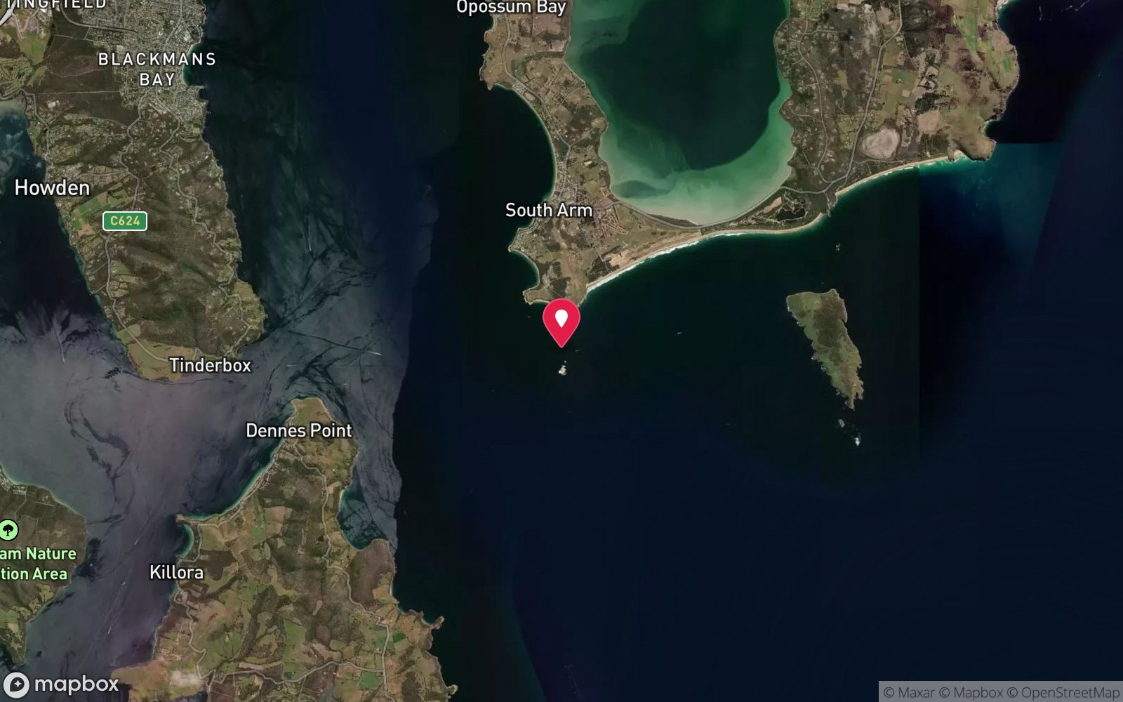
No published coordinates. The map above shows the general area, estimated from other documented sites near South Arm.
Primary source: marinelife.org.auMarine park & permits
Scuttled vessels – no permit required; do not remove material. Historic wrecks older than 75 years are protected.
Nearest recompression chamber
Royal Hobart Hospital Hyperbaric Medicine Unit (Hobart CBD); DAN emergency hotline 1800 088 200
Diving emergency: call 000, then DAN AP 1800 088 200.
Trip planner
Build a trip around Tug Boyer (Betsey Island) →
A day-by-day plan for Hobart & Derwent with this site locked in.
This guide is a planning aid. Conditions change daily — confirm with a local dive centre and dive within your training. Data & safety notes.
Dive profile
How this site rates
Scores are computed from the recorded data, not opinions. How?
At a glance
Tug Boyer (Betsey Island) is a wreck boat dive in Hobart & Derwent, TAS, 17–20 m, suited to Advanced Open Water divers, about 18 minutes by boat.
Rated intermediate because of depth beyond 18 m, boat traffic overhead, cold water.
Why dive here
- Intact hull of the Derwent's last working steam tug, beside the Macquarie.
- Rarely dived: expect to have the site to yourself, and plan your own logistics.
Conditions to avoid
- Strong southerly or south-east swell and wind
- Outgoing tide or run-off after rain (poor visibility)
About Tug Boyer (Betsey Island)
The Betsey Island graveyard, west of Little Betsey Island at the mouth of the Derwent, is Hobart's ships' graveyard: from the 1930s to the 1980s obsolete vessels, barges and sections of the old floating bridge were towed here and scuttled in about 20-34 m. The Marine Life Network guide calls it a huge concentration of wreck dives very close to Hobart, with a pebble-and-mud bottom that stirs up easily, poor visibility after bad weather or decaying Storm Bay swell, and massive yellow and white jewel anemones and, at times, hordes of school fish on the wrecks. The Boyer was a steam turbine-driven tug and, according to the guide, the last working steam vessel on the Derwent.
She was 60 tons and was scuttled close to the Macquarie in the 1980s. Her hull is intact, although most of the superstructure was removed before scuttling, leaving a compact, tug-shaped hull sitting on the bottom in about 20 m. Its small size makes it easy to circle in a few minutes, and its intact shape makes it one of the more satisfying wrecks in the graveyard despite the low visibility.
Jewel anemones and encrusting growth cover the hull, and schools of small fish hang over it. The tug is named after Boyer, the site of the Australian Newsprint Mills paper mill up the Derwent, whose paper was carried downriver by barges – some of which now lie scuttled nearby. The Boyer, the barges and the Macquarie together form a cluster that can be explored on one dive in reasonable visibility.
Because the superstructure is gone, there is little to penetrate, and divers should stay outside the hull. The wreck is a tangible piece of Hobart's working-harbour history, from the era when steam tugs handled the river's shipping.
Wreck details
Steel steam turbine tug, 60 tons
Getting there & entry
Intact hull of the steam turbine-driven tug Boyer, the last working steam vessel on the Derwent, scuttled in the 1980s close to the Macquarie in about 20 m.
South Arm is about 35 km (40 minutes) south-east of Hobart: cross the Tasman Bridge, follow the South Arm Highway (B33) through Rokeby and Lauderdale to South Arm. The main boat ramp is at South Arm (Blessington Street/Harbour area) with trailer parking and toilets; Lauderdale (Doran's Road) is an alternative ramp further north. From South Arm the Betsey Island graveyard lies about 5-6 km south-east across the mouth of the Derwent, west of Little Betsey Island, roughly 15-20 minutes by boat.
The Marine Life Network guide recommends an echo sounder to locate the individual wrecks, which are low on the bottom; there are no public moorings, so anchor carefully in the pebble-mud bottom off the wreck and leave a boat attendant.
Entry: Back roll or giant stride from charter boat
Facilities: South Arm and Lauderdale boat ramps; fills in Hobart.
Weather, swell & tides
Betsey Island lies at the mouth of the Derwent where it meets Storm Bay, so decaying southerly swell and strong southerly or south-westerly winds make the ride rough and stir up the pebble-and-mud bottom. The Marine Life Network notes the graveyard is not renowned for visibility and recommends calm, dry weather and an ebb tide, when clearer water sits over the wrecks. After Derwent floods the water can be very dark.
Northerly and light westerly winds give the best conditions; late summer and autumn are most reliable. Expect 3-8 m visibility at best, often less.
Best season: Late summer to autumn (February-May) for settled weather and best visibility; diveable year-round between fronts
How the dive is usually run
Visit from the Macquarie or shot the Boyer directly; circle the intact hull, look into the open deck areas without entering, and return to the shot.
Marine life
- Jewel anemones
- encrusting invertebrates
- small schooling fish
- leatherjackets
- crabs
Linked species have their own page listing every site where they are recorded. All marine life →
Training required
Beyond 18 m an Advanced certification (which includes a deep dive to 30 m) is the accepted minimum. Anything past 25 m is a deep dive in practice.
Courses that help here
- Drysuit Diver – Cold water; locals dive dry for much of the year.
- Peak Performance Buoyancy – Silt and low visibility punish poor trim.
Depth tiers: 0–10 m easy · to 18 m Open Water · 18–30 m Advanced (25 m+ is a deep dive) · 30–40 m Deep specialty · 40 m+ technical. All courses
Hazards & warnings
Low visibility; silt; do not enter the hull; boat traffic.
Dive centres that go here
No scheduled operator trips; Hobart clubs (Tasmanian Scuba Diving Club and others) and private boats from South Arm and Lauderdale. The Dive Shop Hobart and Go Dive Tasmania can advise.
Operators recorded for Tug Boyer (Betsey Island)
Other dive centres in Hobart & Derwent
Tasmania Tech and Dive Centre
ProfiledHobart & Derwent · TAS
The Tasmanian operation most clearly associated with technical diving services, spanning recreational and technical training with technical gas support.
Tasmanian Divers North
ListedLaunceston · Tasmania North & North-West · TAS
A northern Tasmanian operation serving the Bass Strait coastline and local diving community.
tasdivers.com.au · (03) 6229 1020
Tasmanian Divers South
ListedKingston · Hobart & Derwent · TAS
A southern Tasmanian operation serving the Hobart region and surrounding diving.
tasdivers.com.au · (03) 6229 1020
The Dive Shop Hobart
ListedHobart · Hobart & Derwent · TAS
A Hobart equipment and service business supporting local cold-water divers.
thediveshophobart.com.au · (03) 6234 3428
Underwater Adventures Tasmania
Reported closedBattery Point · Bruny Island & D'Entrecasteaux Channel · TAS
Reported permanently closed on Tripadvisor; last reviews 2013; formerly ran from Battery Point jetty (underwateradventures.com.au).
General area
No position has been published for Tug Boyer (Betsey Island). The circle shows where it is likely to be, worked out from other documented sites near South Arm. Ask a local operator for the exact site.
Dashed circle: general area (about 7 km), from other documented sites near South Arm. 6 pinned sites. Pins marked approximate on their pages show the general area only; not for navigation.
Tug Boyer (Betsey Island): frequently asked questions
How deep is Tug Boyer (Betsey Island)?
Tug Boyer (Betsey Island) reaches a maximum depth of 20 m, with the shallowest part at about 17 m; most of the dive is spent around 19 m.
What certification do I need to dive Tug Boyer (Betsey Island)?
Advanced Open Water is the recommended minimum. Rated intermediate because of depth beyond 18 m, boat traffic overhead, cold water.
Can I shore dive Tug Boyer (Betsey Island)?
No, it is reached by boat (about 18 minutes). A dive centre is required: boat access only.
When is the best time to dive Tug Boyer (Betsey Island)?
Late summer to autumn (February-May) for settled weather and best visibility; diveable year-round between fronts.
What marine life will I see at Tug Boyer (Betsey Island)?
Regularly recorded: Jewel anemones, encrusting invertebrates, small schooling fish, leatherjackets, crabs.
What wetsuit do I need at Tug Boyer (Betsey Island)?
Drysuit strongly recommended year-round; 7 mm semi-dry or two-piece 7 mm wetsuit with hood and gloves is the minimum in summer.
How cold is the water at Tug Boyer (Betsey Island)?
Typically 14-18 °C in summer and 9-12 °C in winter.
What are the main hazards at Tug Boyer (Betsey Island)?
Low visibility; silt; do not enter the hull; boat traffic. See the hazards section above for the full list.
Where is the nearest recompression chamber to Tug Boyer (Betsey Island)?
Royal Hobart Hospital Hyperbaric Medicine Unit (Hobart CBD); DAN emergency hotline 1800 088 200. In an emergency call 000, then DAN Asia-Pacific on 1800 088 200.
Diving in Hobart & Derwent
Hobart has the Tinderbox Marine Reserve, with its snorkel trail, weedy seadragons and easy shore access, the Derwent's wrecks and the Alma dredge, the Blackmans Bay and Kingston reefs, and the Iron Pot at the river mouth. Water is 11–17 °C and visibility improves quickly downstream of the city.
Getting there: All within 30–40 minutes of the city with shore entries; Hobart dive shops run charters and hire drysuits.
Sources
Data confidence: Low · Being verified: Scuttling year given only as 1980s; positions not published; single older source.. Last updated September 2026. Know this site better? How to send a correction