Dive slate · divesites.com.au · printed 9 Nov 2026
The Rip (Direction Island)
Cocos (Keeling) Islands, External Territories · near Home Island / West Island (by ferry)
| Depth | 1–8 m |
|---|---|
| Minimum level | Snorkel/Any |
| Difficulty | Intermediate |
| Access | Shore or Boat |
| Entry | Walk in from the beach near the last picnic table (reef shoes) or drop off by boat at the seaward end; drift into the lagoon |
| Current | Strong |
| Visibility | 20-30 m |
| Water | summer 28-29 °C, winter 26-27 °C |
| Suit | 3 mm wetsuit or rash vest year-round |
| Best season | Year-round; slower, easier flow around low tide; calmest November–April |
| Position | -12.09200, 96.88300 (approximate) |
| Permit | Cocos (Keeling) Islands Marine Park – National Park (green) zone around The Rip: no fishing or take; snorkelling and diving allowed without permit |
| Nearest chamber | Fiona Stanley Hospital (Perth) – about 2,700 km away via aeromedical evacuation; there is no recompression chamber on Cocos or Christmas Island |
| Emergency | 000 · DAN Asia-Pacific diving emergency 1800 088 200 |
The Rip (Direction Island)
Also known as The Rip, Direction Island Rip, Rip Site
A fast, coral-lined drift channel from the ocean into the lagoon, full of sharks, humphead parrotfish and Napoleon wrasse, with a safety rope to stop and watch.
Near Home Island / West Island (by ferry) · Cocos (Keeling) Islands, External Territories
- Depth
- 1–8 m
- Minimum level
- Snorkel/Any
- Access
- Shore or Boat
- Boat ride
- —
- Water
- 28-29 °C
- Visibility
- 20-30 m
The Rip (Direction Island)1–8 m · Snorkel/Any · Shore
Dive factsDepths, conditions, location & safety
Season
In season nowBest months: January, February, March, April, November, December.
Year-round; slower, easier flow around low tide; calmest November–April
- Best months
- Now (November)
- Stinger suit Nov–May
Dive facts
- Depth
- 1–8 m
- Typical depth
- 4 m
- Certification
- Snorkel/Any
- Difficulty
- Intermediate
- Depth tier
- Easy (0–10 m)
- Access
- Shore or Boat
- Dive centre needed
- No – independently diveable
- Shore / independent
- Possible (experienced only)
- Current
- Strong
- Visibility
- 20-30 m
- Water temp (summer)
- 28-29 °C
- Water temp (winter)
- 26-27 °C
- Water
- Tropical
- Dive traffic
- Very popular (dived daily)
- Night dive
- No
- Snorkel friendly
- Yes
Exposure suit
3 mm wetsuit or rash vest year-round
Location
Direction Island (Pulu Tikus) · Cocos (Keeling) Islands – Indian Ocean
-12.09200, 96.88300
Approximate position — not for navigation.
Open in Google MapsDive site map (external) →Primary source: cocoskeelingislands.com.auMarine park & permits
Cocos (Keeling) Islands Marine Park – National Park (green) zone around The Rip: no fishing or take; snorkelling and diving allowed without permit
Nearest recompression chamber
Fiona Stanley Hospital (Perth) – about 2,700 km away via aeromedical evacuation; there is no recompression chamber on Cocos or Christmas Island
Diving emergency: call 000, then DAN AP 1800 088 200.
Trip planner
Build a trip around The Rip (Direction Island) →
A day-by-day plan for Cocos (Keeling) Islands with this site locked in.
This guide is a planning aid. Conditions change daily — confirm with a local dive centre and dive within your training. Data & safety notes.
Dive profile
How this site rates
Scores are computed from the recorded data, not opinions. How?
At a glance
The Rip (Direction Island) is a drift shore dive for experienced divers in Cocos (Keeling) Islands, Australia's external territories, 1–8 m, suitable for snorkellers and first-time divers, strong current.
Rated intermediate because of strong current, boat traffic overhead.
Why dive here
- A fast, coral-lined drift channel from the ocean into the lagoon, full of sharks, humphead parrotfish and Napoleon wrasse, with a safety rope to stop and watch.
- Snorkel-friendly, so non-diving companions can join at the surface.
- Visibility often reaches 20-30 m.
Conditions to avoid
- Strong southerly or south-east swell and wind
- Spring tides (strong current)
About The Rip (Direction Island)
The Rip is Australia's best-known drift snorkel and the one experience almost every Cocos visitor seeks out. At the eastern end of Direction Island a narrow channel cuts through the reef, and ocean water floods through it continuously into the lagoon, creating what the official tourism site calls a natural drift snorkel known worldwide. Snorkellers enter at the seaward end and are carried through a coral-lined channel a few metres deep before being released into the calm, shallow lagoon – a ride likened by Diveplanit to a waterslide.
The channel is full of fish that sit in the flow: humphead parrotfish, Napoleon (humphead) wrasse, bluefin trevally, groupers and snapper, with reef sharks – blacktips, whitetips and grey reef sharks – cruising or holding position in the current. Barracuda to 1.5 m, morays, turtles, angelfish, butterflyfish and neon damsels are all regularly seen, and the coral cover along the walls is high – SSI's feature estimated about 70%. Divers sometimes run it on scuba, and Cocos Dive has recorded mantas passing through.
A safety rope is strung in the channel so snorkellers can stop and hang on to watch the sharks. The edges are calmer than the centre, making it manageable for competent swimmers, but the current is strong, especially on high tides, and there are no lifeguards. Direction Island itself adds to the day: Cossies Beach on the lagoon side has been voted Australia's best beach, and the island carries history from the Eastern Extension cable station (from 1901) and the Emden landing party of 1914.
The waters around The Rip are one of two small inshore National Park (green) zones in the marine park, so no fishing is allowed. Most people make several runs, seeing more each time.
Getting there & entry
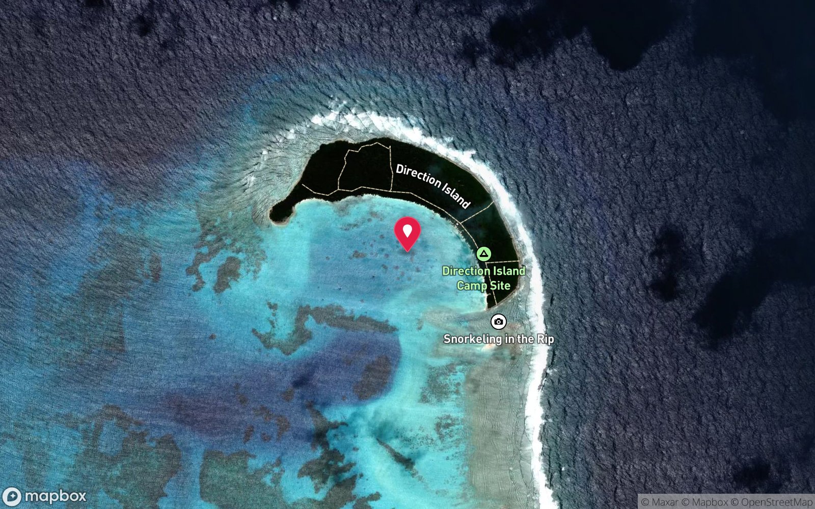
Narrow channel at the eastern end of Direction Island, between it and the reef towards Prison Island, where ocean water floods into the lagoon; a short walk from the Direction Island jetty.
The public ferry runs from West Island (and Home Island) to Direction Island twice a week, on Thursdays and Saturdays; the return fare is $5 per person, cash on board, and the return boat leaves Direction Island in the early afternoon (around 2 pm – be at the jetty or be stranded). Check the current Shire timetable on arrival. From the Direction Island jetty follow the track east about 10 minutes to the viewing platform over The Rip, or turn toward the beach at the last picnic table for the easiest entry.
Walk up the shore to the seaward end, enter, drift through the channel and exit on the lagoon beach, then walk back and repeat. Cocos Dive's Monday-morning sea-scooter tours and local skippers can drop snorkellers at the top of the channel and collect them in the lagoon.
Entry: Walk in from the beach near the last picnic table (reef shoes) or drop off by boat at the seaward end; drift into the lagoon
Facilities: Direction Island: eco toilets, picnic tables, wood-fired BBQs, shelters (pondoks); no shops, food or drinking water – bring everything.
Weather, swell & tides
The Rip is a tidal channel: ocean water pours through it into the lagoon, and the speed depends on the tide, the swell and the moon phase – Dive Pacific reports up to 4 knots. High and incoming tides, spring tides around full and new moon, and big south-east swell pushing water over the reef all make it faster; low tide gives the slowest flow and suits weaker swimmers and those wanting to linger. In strong trade winds (April–October) the surface is choppy and the entry rougher, but the snorkel still runs; the doldrum season (November–April) gives the calmest water.
Visibility is best on the incoming tide. Plan the day around the ferry times, which fix when you can be there.
Best season: Year-round; slower, easier flow around low tide; calmest November–April
If it's blown out
Sheltered or shore sites within 25 km that often work when The Rip (Direction Island) doesn't.
- Broccoli Patch · 0 km · Max 10 m
- Phaeton Wreck · 3 km · Max 6 m
- Pulu Maraya · 10 km · Max 5 m
- Direction Island Unidentified Wreck · 1 km · Max 4 m
How the dive is usually run
Walk to the seaward end of the channel, enter from the shore and relax face-down; let the current carry you through, holding the safety rope to stop and look if needed. Stay near the channel edges for calmer water, or in the centre for the full ride. Once in the lagoon the flow slackens – swim to the beach, walk back and repeat.
Never swim against the current.
Marine life
- Reef sharks (blacktip, whitetip, grey reef) →
- humphead parrotfish
- Napoleon wrasse
- bluefin and giant trevally
- groupers
- snapper
- barracuda
- morays
- turtles →
- stingrays
- triggerfish
- angelfish
- butterflyfish
- neon damsels
- occasional manta rays →
Linked species have their own page listing every site where they are recorded. All marine life →
Training required
Shallow enough for snorkellers and for a first dive under supervision. Any certified diver can dive it.
Courses that help here
- Drift Diver – Current is a feature of the dive.
Depth tiers: 0–10 m easy · to 18 m Open Water · 18–30 m Advanced (25 m+ is a deep dive) · 30–40 m Deep specialty · 40 m+ technical. All courses
Hazards & warnings
Strong current (to about 4 knots on big tides) – never swim against it; go with a buddy; no lifeguards. Fins are essential for anything beyond passive drifting; reef shoes for the rocky shore. Choose low tide if not a strong swimmer.
Don't miss the return ferry. Sunburn. Nearest medical care is the West Island clinic by boat; no chamber (Fiona Stanley Hospital, Perth, by aeromedical evacuation).
Dive centres that go here
Mostly self-guided via the public ferry. Cocos Dive runs sea-scooter snorkel tours at The Rip most Monday mornings (limited places) and dives the channel on its trips; local skippers and lagoon tours offer drop-off and pickup.
Operators recorded for The Rip (Direction Island)
Cocos Dive
ListedWest Island · Cocos (Keeling) Islands · WA
The main dive operation in the Cocos Keeling Islands, servicing atoll and outer reef diving.
cocosdive.com · 0498 080 187
Cocos Blue Charters
Named by sitesWest Island · Cocos (Keeling) Islands · External Territory
Charter boat operator (dive/fishing/snorkel charters).
cocosblue.com.au · (08) 9162 6579
Cocosday Tours
Named by sitesWest Island · Cocos (Keeling) Islands · External Territory
Boat tours, fishing, motorised canoe tours and boat hire; not a scuba dive shop.
cocosislandsboatandfishing.com · (08) 9162 7741
Map
7 pinned sites. Pins marked approximate on their pages show the general area only; not for navigation.
Satellite views
The Rip (Direction Island): frequently asked questions
How deep is The Rip (Direction Island)?
The Rip (Direction Island) reaches a maximum depth of 8 m, with the shallowest part at about 1 m; most of the dive is spent around 4 m.
What certification do I need to dive The Rip (Direction Island)?
No certification is needed to snorkel it, and it suits introductory dives. Rated intermediate because of strong current, boat traffic overhead.
Can I shore dive The Rip (Direction Island)?
Experienced divers do dive The Rip (Direction Island) from the shore, but the entry or conditions make it unsuitable for newer divers without local guidance. Entry: Walk in from the beach near the last picnic table (reef shoes) or drop off by boat at the seaward end; drift into the lagoon.
When is the best time to dive The Rip (Direction Island)?
Year-round; slower, easier flow around low tide; calmest November–April.
What marine life will I see at The Rip (Direction Island)?
Regularly recorded: Reef sharks (blacktip, whitetip, grey reef), humphead parrotfish, Napoleon wrasse, bluefin and giant trevally, groupers, snapper, barracuda, morays, turtles, stingrays, triggerfish, angelfish and more.
What wetsuit do I need at The Rip (Direction Island)?
3 mm wetsuit or rash vest year-round.
How cold is the water at The Rip (Direction Island)?
Typically 28-29 °C in summer and 26-27 °C in winter.
What are the main hazards at The Rip (Direction Island)?
Strong current (to about 4 knots on big tides) – never swim against it; go with a buddy; no lifeguards. See the hazards section above for the full list.
Where is the nearest recompression chamber to The Rip (Direction Island)?
Fiona Stanley Hospital (Perth) – about 2,700 km away via aeromedical evacuation; there is no recompression chamber on Cocos or Christmas Island. In an emergency call 000, then DAN Asia-Pacific on 1800 088 200.
Diving in Cocos (Keeling) Islands
Cocos is a true coral atoll 2,750 km north-west of Perth, with 27 islands around a shallow turquoise lagoon and an outer reef that drops to deep water. Manta rays feed in the channels, green turtles are everywhere, dolphins visit the boats, and the outer walls hold grey reef sharks, tuna and huge schools of fusiliers. Two sites, the Cabbage Patch and the Rip, are among the best drift dives in the Indian Ocean.
Getting there: Fly from Perth via Christmas Island. One operator on West Island runs boat dives on the outer reef and lagoon; some lagoon sites can be reached by kayak or a long swim.
All Cocos (Keeling) Islands dive sites and a suggested itinerary →
Sources
- cocoskeelingislands.com.au/things-to-do/see-do/activities/direction-island-3
- cocoskeelingislands.com.au/things-to-do/see-do/activities/snorkelling
- snorkelspots.com/the-rip-snorkel
- willparker.com.au/guide-to-direction-island-while-visiting-the-cocos-islands
- divepacific.co.nz/post/dive-destination-cocos-keeling-island
- underwater.com.au/article/id/2181-destination-cocos-keeling-islands
- diveplanit.com/dive-destination/cocos-keeling-islands
- divessi.com/en/blog/ssi-edges-of-earth-diving-cocos-keeling-islands-10257.html
- australianmarineparks.gov.au/parks/indian-ocean-territories-marine-parks/cocos-keeling-islands-marine-park
- christmas.net.au/cocos-dive
- en.wikipedia.org/wiki/Direction_Island
Data confidence: High · Being verified: Ferry days and return time should be checked on arrival. Channel orientation described as between Direction Island's east end and the Prison Island reef (Will Parker).. Last updated September 2026. Know this site better? How to send a correction
Nearby dive sites
More drift dives in External Territories
Explore more
This region
Similar dives
Marine life